Showing posts with label Kraken Mare. Show all posts

Friday, October 31, 2014

Sunglint South of Titan's Kraken Mare


This near-infrared, color mosaic from NASA's Cassini spacecraft shows the sun glinting off of Titan's north polar seas. While Cassini has captured, separately, views of the polar seas (see PIA17470) and the sun glinting off of them (see PIA12481 and PIA18433) in the past, this is the first time both have been seen together in the same view.

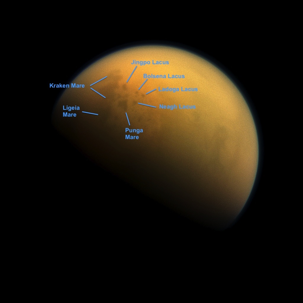
The sunglint, also called a specular reflection, is the bright area near the 11 o'clock position at upper left. This mirror-like reflection, known as the specular point, is in the south of Titan's largest sea, Kraken Mare, just north of an island archipelago separating two separate parts of the sea.

This particular sunglint was so bright as to saturate the detector of Cassini's Visual and Infrared Mapping Spectrometer (VIMS) instrument, which captures the view. It is also the sunglint seen with the highest observation elevation so far -- the sun was a full 40 degrees above the horizon as seen from Kraken Mare at this time -- much higher than the 22 degrees seen in PIA18433. Because it was so bright, this glint was visible through the haze at much lower wavelengths than before, down to 1.3 microns.

The southern portion of Kraken Mare (the area surrounding the specular feature toward upper left) displays a "bathtub ring" -- a bright margin of evaporate deposits -- which indicates that the sea was larger at some point in the past and has become smaller due to evaporation. The deposits are material left behind after the methane & ethane liquid evaporates, somewhat akin to the saline crust on a salt flat.

The highest resolution data from this flyby -- the area seen immediately to the right of the sunglint -- cover the labyrinth of channels that connect Kraken Mare to another large sea, Ligeia Mare. Ligeia Mare itself is partially covered in its northern reaches by a bright, arrow-shaped complex of clouds. The clouds are made of liquid methane droplets, and could be actively refilling the lakes with rainfall.

The view was acquired during Cassini's August 21, 2014, flyby of Titan, also referred to as "T104" by the Cassini team.

The view contains real color information, although it is not the natural color the human eye would see. Here, red in the image corresponds to 5.0 microns, green to 2.0 microns, and blue to 1.3 microns. These wavelengths correspond to atmospheric windows through which Titan's surface is visible. The unaided human eye would see nothing but haze, as in PIA12528.

Image credit: NASA/JPL-Caltech/University of Arizona/University of Idaho

Note: For more information, see PIA18433: Sunglint on a Hydrocarbon Lake and Cassini Sees Sunny Seas on Titan.

Wednesday, June 18, 2014

Radio Occultation of Titan During Cassini Flyby


Cassini will attempt to bounce signals off of Saturn's moon Titan once more during a flyby on June 18, 2014, revealing important details about the moon's surface.

As NASA's Cassini spacecraft zooms toward Saturn's smoggy moon Titan for a targeted flyby on June 18, mission scientists are excitedly hoping to repeat a scientific tour de force that will provide valuable new insights into the nature of the moon's surface and atmosphere.

For Cassini's radio science team, the last flyby of Titan, on May 17, was one of the most scientifically valuable encounters of the spacecraft's current extended mission. The focus of that flyby, designated "T-101," was on using radio signals to explore the physical nature of Titan's vast northern seas and probe the high northern regions of its substantial atmosphere.

The Cassini team hopes to replicate the technical success of that flyby during the T-102 encounter, slated for June 18, during which the spacecraft will attempt similar measurements of Titan. During closest approach, the spacecraft will be just 2,274 miles (3,659 kilometers) above the surface of the moon while traveling at 13,000 miles per hour (5.6 kilometers per second).

During the upcoming flyby, if all goes well as before, Cassini's radio science subsystem will bounce signals off the surface of Titan, toward Earth, where they will be received by the ground stations of NASA's Deep Space Network. This sort of observation is known as a bistatic scattering experiment and its results can yield clues to help answer a variety of questions about large areas of Titan's surface: Are they solid, slushy or liquid? Are they reflective? What might they be made of?

During the May encounter, Cassini beamed radio signals over the two largest bodies of liquid on Titan, seas named Ligeia Mare and Kraken Mare. During that first attempt, scientists could not be certain the signals would successfully bounce off the lakes to be received on Earth. They were thrilled when ground stations received specular reflections -- essentially the glint -- of the radio frequencies as they ricocheted off Titan.

"We held our breath as Cassini turned to beam its radio signals at the lakes," said Essam Marouf, a member of the Cassini radio science team of San Jose State University in California. "We knew we were getting good quality data when we saw clear echoes from Titan's surface. It was thrilling."

A second technical accomplishment -- an experiment to send precision-tuned radio frequencies through Titan's atmosphere -- also makes the May and June flybys special. The experiment, known as a radio occultation, provides information about how temperatures vary by altitude in Titan's atmosphere. Preparing for these experiments tested just how thoroughly the Cassini team has come to understand the structure of Titan's atmosphere during nearly a decade of study by the mission.

During this type of radio occultation, a signal is beamed from Earth through the atmosphere of Titan toward the Cassini spacecraft, which responds back to Earth with an identical signal. Information about Titan is imprinted in the signal as it passes through the moon's atmosphere, encountering differences in temperature and density. The trick is that the transmitted signal must be varied during the experiment so that it remains nearly constant when received by the spacecraft.

In order to give the occultation experiments any chance of success, the team has to account for not only the relative motions of the spacecraft and the transmitting antennas on the rotating planet Earth, but also the ways the signal is bent by different layers in Titan's atmosphere.

While this procedure has been used successfully for several Saturn occultations in the past two years, it had not yet been tried at Titan. And since the Titan occultations last just a few minutes, the team was concerned about how quickly the frequency lockup between ground and spacecraft could be established, if at all. For comparison, NASA's Magellan mission tried the technique at Venus in the 1990s, without success.

As they waited for signs of confirmation during the May encounter, the team saw the signal lock occur in only a few seconds, indicating that their predictions were spot-on. Data on Titan's atmosphere flowed in, adding new information to the mission's campaign to monitor the changing of the seasons on this alien moon.

"This was like trying to hit a hole-in-one in golf, except that the hole is close to a billion miles away, and moving," said Earl Maize, Cassini project manager at NASA's Jet Propulsion Laboratory in Pasadena, California. "This was our first attempt to precisely predict and compensate for the effect of Titan's atmosphere on the uplinked radio signal from Earth, and it worked to perfection."

Illustration credit: NASA/JPL-Caltech

Monday, December 30, 2013

Lakes and Seas of Titan


Using a special spectral filter, the high-resolution camera aboard NASA's Cassini spacecraft was able to peer through the hazy atmosphere of Saturn's moon Titan. It captured this image, which features the largest seas and some of the many hydrocarbon lakes that are present on Titan's surface. Titan is the only place in the solar system, other than Earth, that has stable liquids on its surface. In this case, the liquid consists of ethane and methane rather than water. Figure 1 indicates the names assigned to the visible features. Titan's largest sea is Kraken Mare.

For more information on Titan's hydrocarbon lakes see PIA17472 and PIA17473.

This view looks towards the side of Titan (3,200 miles or 5,150 kilometers across) that leads in its orbit around Saturn. North on Titan is up and rotated 36 degrees to the left. Images taken using red, green and blue spectral filters were combined to create this natural-color view. The images were taken with the Cassini spacecraft narrow-angle camera on October 7, 2013.

The view was acquired at a distance of approximately 809,000 miles (1.303 million kilometers) from Titan. Image scale is 5 miles (8 kilometers) per pixel.


Photo credit: NASA/JPL-Caltech/Space Science Institute

Note: For more information, see Cassini Sees Saturn and Moons in Holiday Dress.

Friday, December 13, 2013

Titan - Extraterrestrial Land of Lakes


This colorized flyover movie from NASA's Cassini mission shows the two largest seas on Saturn's moon Titan and nearby lakes. Titan is the only world in our solar system other than Earth that has stable liquid on its surface. The liquid in Titan's lakes and seas is mostly methane and ethane.

The flight path starts at Titan's largest sea, Kraken Mare (about 680 miles or 1,100 kilometers long), and passes over the second largest sea, Ligeia Mare. Titan seas are named after sea monsters in world mythology. Then, there is an area with no topographical data and the flight path crosses an area with smaller lakes.

Lakes in this area are about 30 miles (50 kilometers) across or less.

Data for the movie was obtained by Cassini's radar instrument from 2004 to 2013. Heights of features were exaggerated 10 times. In this color scheme, liquids appear blue and black. Land areas appear yellow to white. A haze was added to simulate the Titan atmosphere.

Straight lines in the images are artifacts of how Cassini obtained the data.

The topographic mapping of Titan using stereo radar images was performed by the U.S. Geological Survey in Flagstaff, Arizona. The animation was created at JPL.

Video credit: NASA/JPL-Caltech/ASI/USGS

Note: For more information, see PIA17655: Titan's North and NASA's Cassini Spacecraft Reveals Clues About Saturn Moon

Thursday, October 24, 2013

Titan's North Polar Lakes and Evaporite Deposits


This false-color mosaic, made from infrared data collected by NASA's Cassini spacecraft, reveals the differences in the composition of surface materials around hydrocarbon lakes at Titan, Saturn's largest moon. Titan is the only other place in the solar system that we know has stable liquid on its surface, though its lakes are made of liquid ethane and methane rather than liquid water. While there is one large lake and a few smaller ones near Titan's south pole, almost all of Titan's lakes appear near the moon's north pole.

Scientists mapped near-infrared colors onto the visible color spectrum. Red in this image was assigned a wavelength of 5 microns (10 times longer than visible light), green 2.0 microns (four times longer than visible light), and blue 1.3 microns (2.6 times longer than visible light).

The orange areas are thought to be evaporite -- the Titan equivalent of salt flats on Earth. The evaporated material is thought to be organic chemicals originally from Titan's haze particles that once dissolved in liquid methane. They appear orange in this image against the greenish backdrop of Titan's typical bedrock of water ice.

In this mosaic, Kraken Mare, which is Titan's largest sea and covers about the same area as Earth's Caspian Sea and Lake Superior combined, can be seen spreading out with many tendrils on the upper right,. The big dark zone up and left of Kraken is Ligeia Mare, the second largest sea. Below Ligeia, shaped similar to a sports fan's foam finger that points just up from left, is Punga Mare, the third largest Titan Sea. Numerous other smaller lakes dot the area. Titan's north pole is located in the geographic location just above the end of the "finger" of Punga Mare.

Figure 1 highlights a high-resolution strip and shows the north pole marked with a red cross. Other smaller lakes are also labeled.

The data shown here were obtained by Cassini's visual and infrared mapping spectrometer during a close flyby of Titan on September 12, 2013.

Until now, the spectrometer has only been able to capture distant, oblique or partial views of this area. The September 12, 2013, flyby provided better viewing geometry. And sunlight has begun to pierce the winter darkness that shrouded Titan's north pole at the time of Cassini's arrival in the Saturn system nine years ago. A thick cap of haze that once hung over the north pole has also dissipated as northern summer approaches. And, thankfully, Titan's beautiful, almost cloudless, rain-free weather continued during this flyby.

The resolution varies across this composite view depending on when each cube of data was acquired, but the best surface sampling is 2 miles (3 kilometers) per pixel.

Views of this area by other Cassini instruments include PIA17471, PIA17472, PIA17473 and PIA14584 from the imaging science subsystem; and PIA10008 and PIA17031 from the radar mapper. An earlier VIMS view can be seen at PIA16845.


Image credit: NASA/JPL-Caltech/University of Arizona/University of Idaho

Note: For more information, see Cassini Gets New Views of Titan's Land of Lakes.

Wednesday, April 17, 2013

Wetlands on Titan


A dense network of small rivers or swampy areas appears to connect some of the seas on Saturn's moon Titan, as seen in this comparison of data of the same area from two instruments on NASA's Cassini spacecraft. Images from the radar instrument are on the left and images from the visual and infrared mapping spectrometer (VIMS) are on the right.

At approximately 50,000 square miles (about 125,000 square kilometers), Ligeia Mare (middle of the images) is larger than any North American lake. The labels K1, K2, and K3 in the radar mosaic (a) refer to different parts of Kraken Mare that appear interconnected in the VIMS mosaic (b).

Photo credit: NASA/JPL-Caltech/University of Arizona

Note: For more information, see Titan's Methane: Going, Going, Soon to Be Gone?

Thursday, December 13, 2012

Titan's Nile-like River


A miniature version of the Nile River, seen on Saturn’s moon Titan by the international Cassini mission. The river valley stretches more than 400 km from its ‘headwaters’ to a large sea, and likely contains hydrocarbons.

The image was acquired on 26 September 2012, on Cassini’s 87th close flyby of Titan. The river valley crosses Titan’s north polar region and runs into Kraken Mare, one of the three great seas in the high northern latitudes of the moon.

Photo credit: NASA/JPL–Caltech/ASI

Note: For more information, see Titan's Nile-Like River Valley.

Sunday, February 26, 2012

Changes in Titan's North Polar Cloud


This series of images obtained by NASA's Cassini spacecraft shows several views of the north polar cloud covering Saturn's moon Titan. The false-color images were obtained by Cassini's Visual and Infrared Mapping Spectrometer (VIMS). They can be seen on the left of each pair of images, with that same image re-projected onto a globe of Titan on the right. The global image shows Titan's north pole at the center. Other parts of the Titan globe are filled in using data from Cassini's imaging cameras and radar instrument.

The VIMS images cover 2006 to 2009, when Titan was transitioning from northern winter to northern spring. In 2006, the north polar cloud appeared dense and opaque. But in spectrometer images obtained around the 2009 equinox, when the Sun was directly over Saturn and Titan's equators and northern winter was turning into spring, the cloud appeared much thinner and patchier. It allowed scientists to see the underlying northern lakes and seas on the surface, including Kraken Mare (at the end of the red arrows). The northern seas and lakes, made of liquid hydrocarbons, look like dark jigsaw puzzle pieces in the false-color images.

Scientists colorized the VIMS image by assigning red, green and blue to the parts of the infrared spectrum around 5 micrometers, 2.8 micrometers and 2.03 micrometers, respectively. The images create a kind of time-lapse series from December 28, 2006 to June 6, 2009, from the 23rd, 24th, 30th, 43rd, 44th, 45th, 52nd, 53rd, 55th and 57th time Cassini flew by Titan. (Planning changes early in the orbital tour meant that even though a Titan flyby might be called "T22," it was actually the 23rd flyby of Titan.)

For a view of just the VIMS images, see PIA15230.

Photo credit: NASA/JPL-Caltech/University of Arizona/CNRS/LPGNantes

Saturday, February 25, 2012

Snapshots of Titan's North Polar Cloud


This series of false-color images obtained by NASA's Cassini spacecraft shows the dissolving cloud cover over the north pole of Saturn's moon Titan. The images, obtained by Cassini's Visual and Infrared Mapping Spectrometer (VIMS), cover 2006 to 2009, when Titan was transitioning from northern winter to northern spring. In 2006, the north polar cloud appeared dense and opaque. But in spectrometer images obtained around the 2009 equinox, when the Sun was directly over Saturn and Titan's equators and northern winter was turning into spring, the cloud appeared much thinner and patchier. The dissipating cloud allowed scientists to see the underlying northern lakes and seas, including Kraken Mare. The northern seas and lakes on the surface below, made of liquid hydrocarbons, look like dark jigsaw puzzle pieces in the false-color images.

Scientists colorized the VIMS image by assigning red, green and blue to the parts of the infrared spectrum around 5 micrometers, 2.8 micrometers and 2.03 micrometers, respectively. The images create a kind of time-lapse series from December 28, 2006 to June 6, 2009.

For another view of these images, see PIA15231.

Photo credit: NASA/JPL-Caltech/University of Arizona/CNRS/LPGNantes

Wednesday, November 30, 2011

Kraken Mare


The Cassini spacecraft looks toward Saturn's largest moon, Titan, and spies the huge Kraken Mare in the moon's north.

Kraken Mare, a large sea of liquid hydrocarbons, is visible as a dark area near the top of the image. See PIA12811 and PIA11626 to learn more.

This view looks toward the Saturn-facing side of Titan (3,200 miles across, or 5,150 kilometers,). North on Titan is up and rotated 29 degrees to the left.

The image was taken with the Cassini spacecraft narrow-angle camera on September 14, 2011 using a spectral filter sensitive to wavelengths of near-infrared light centered at 938 nanometers. The view was acquired at a distance of approximately 1.2 million miles (1.9 million kilometers) from Titan and at a Sun-Titan-spacecraft, or phase, angle of 26 degrees. Image scale is 7 miles (12 kilometers) per pixel.

Photo credit: NASA/JPL-Caltech/Space Science Institute