Showing posts with label Enceladus Ocean Hypothesis. Show all posts

Thursday, July 31, 2014

Elevated View of Enceladus' South Pole


This dramatic view looks across the region of Enceladus' geyser basin and down on the ends of the Baghdad and Damascus fractures that face Saturn. The image, which looks approximately in the direction of Saturn, was taken from a more elevated viewpoint than other Cassini survey images of this area of the moon's south pole.

The geysering segments of the fractures seen here are among the most active and warmest in the whole region. As seen from the spacecraft from an elevation angle of 25 degrees south, the jets are projected against the bright surface as opposed to black sky. Consequently, despite the pronounced activity, the jets appear fuzzy, or indistinct, in this image and their tilts are consequently not measurable. Though their source locations are clearly seen, this image was not used in the process of triangulation, but instead it was used to confirm source locations determined from triangulation using other images.

The image was taken with Cassini's narrow-angle camera through the clear filter on August 13, 2010, with an image scale about 230 feet (70 meters) per pixel and a Sun-Enceladus-spacecraft, or phase, angle of about 151 degrees.

This image was one of those used to confirm the sources of Enceladus' geysers as described in a paper by Porco, DiNino, and Nimmo, and published in the online version of the Astronomical Journal in July 2014: http://dx.doi.org/10.1088/0004-6256/148/3/45.

A companion paper, by Nimmo et al. is available at: http://dx.doi.org/10.1088/0004-6256/148/3/46.


Image credit: NASA/JPL-Caltech/Space Science Institute

Note: For more information, see PIA17186: Geyser Basin in 3-D, PIA17187: Enceladus' Plume Brightness Variations, PIA17188: Surveyor's Map of Enceladus' Geyser Basin, PIA17189: What Lies Beneath: Close Up View (Artist's Concept), PIA17190: What Lies Beneath: Regional View (Artist's Concept), and Cassini Spacecraft Reveals 101 Geysers and More on Icy Saturn Moon.

Wednesday, July 30, 2014

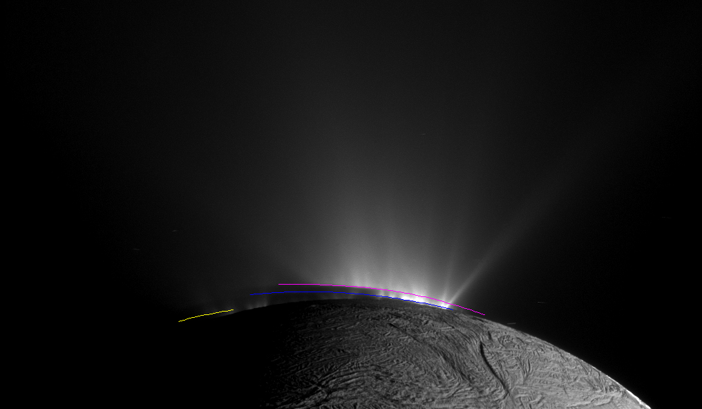
Enceladus Geysers


This Cassini narrow-angle camera image -- one of those acquired in the survey conducted by the Cassini imaging science team of the geyser basin at the south pole of Enceladus -- was taken as Cassini was looking across the moon's south pole. At the time, the spacecraft was essentially in the moon's equatorial plane. The image scale is 1280 feet (390 meters) per pixel and the sun-Enceladus-spacecraft, or phase, angle is 162.5 degrees.

The image was taken through the clear filter of the narrow angle camera on November 30, 2010, 1.4 years after southern autumnal equinox. The shadow of the body of Enceladus on the lower portions of the jets is clearly seen.

In an annotated version of the image, the colored lines represent the projection of Enceladus' shadow on a plane normal to the branch of the Cairo fracture (yellow line), normal to the Baghdad fracture (blue line) and normal to the Damascus fracture (pink line).

Post-equinox images like this, clearly showing the different projected locations of the intersection between the shadow and the curtain of jets from each fracture, were useful for scientists in checking the triangulated positions of the geysers, as described in a paper by Porco, DiNino, and Nimmo, and published in the online version of the Astronomical Journal in July 2014: http://dx.doi.org/10.1088/0004-6256/148/3/45.

A companion paper, by Nimmo et al. is available at: http://dx.doi.org/10.1088/0004-6256/148/3/46.

Image credit: NASA/JPL-Caltech/Space Science Institute

Note: For more information, see 101 Geysers on Icy Saturn Moon.

Friday, April 4, 2014

Enceladus' Ocean


This diagram illustrates the possible interior of Saturn's moon Enceladus based on a gravity investigation by NASA's Cassini spacecraft and NASA's Deep Space Network, reported in April 2014. The gravity measurements suggest an ice outer shell and a low density, rocky core with a regional water ocean sandwiched in between at high southern latitudes.

Views from Cassini's imaging science subsystem were used to depict the surface geology of Enceladus and the plume of water jets gushing from fractures near the moon's south pole.

Enceladus is 313 miles (504 kilometers) in diameter.

Illustration credit: NASA/JPL-Caltech

Note: This is the big story of the day. For more information, see Inside Enceladus, Icy Moon Enceladus Has Underground Sea, NASA Space Assets Detect Ocean inside Saturn Moon, and Deep Ocean Detected Inside Saturn's Moon.

Tuesday, October 5, 2010

The Enceladus Perrier Ocean Hypothesis


This image shows a new explanation for what feeds the mysterious jets spraying from the south polar region of Saturn's moon Enceladus: a subsurface "Perrier" ocean of slightly bubbly seawater. The new model makes sense of data previously collected by NASA's Cassini spacecraft. Cassini had detected sodium and potassium salts and carbonates indicative of a liquid, subsurface ocean. It had also found some organic particles and a large amount of heat flow over a small area. The "Perrier" ocean model appears to explain these phenomena.

This graphic is laid on top of a picture of the Enceladus jets taken by Cassini's imaging cameras in November 2009. It shows bubbles in seawater traveling through a passage in the ice crust to feed a geyser. Seawater flows back down to the subsurface ocean through cracks in the ice.

Image credit: NASA/JPL/Space Science Institute